id
stringclasses 5
values | split
stringclasses 3
values | text
stringclasses 5
values |
|---|---|---|
0000001 | train | h1 |
0000002 | train | h2 |
0000003 | train | h3 |
0000004 | train | h4 |
0000005 | train | h5 |
0000001 | validation | h1 |
0000002 | validation | h2 |
0000003 | validation | h3 |
0000004 | validation | h4 |
0000005 | validation | h5 |
0000001 | test | h1 |
0000002 | test | h2 |
0000003 | test | h3 |
0000004 | test | h4 |
0000005 | test | h5 |
cloudsen12
A dataset about clouds from Sentinel-2
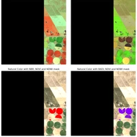
CloudSEN12 is a LARGE dataset (~1 TB) for cloud semantic understanding that consists of 49,400 image patches (IP) that are evenly spread throughout all continents except Antarctica. Each IP covers 5090 x 5090 meters and contains data from Sentinel-2 levels 1C and 2A, hand-crafted annotations of thick and thin clouds and cloud shadows, Sentinel-1 Synthetic Aperture Radar (SAR), digital elevation model, surface water occurrence, land cover classes, and cloud mask results from six cutting-edge cloud detection algorithms. CloudSEN12 is designed to support both weakly and self-/semi-supervised learning strategies by including three distinct forms of hand-crafted labeling data: high-quality, scribble and no-annotation. For more details on how we created the dataset see our paper: CloudSEN12 - a global dataset for semantic understanding of cloud and cloud shadow in Sentinel-2.
ML-STAC Snippet
import mlstac
secret = 'https://huggingface.co/datasets/jfloresf/mlstac-demo/resolve/main/main.json'
train_db = mlstac.load(secret, framework='torch', stream=True, device='cpu')
Sensor: Sentinel 2 - MSI
ML-STAC Task: TensorToTensor, TensorSegmentation
Data raw repository: http://www.example.com/
Dataset discussion: https://github.com/IPL-UV/ML-STAC/discussions/2
Review mean score: 5.0
Split_strategy: random
Paper: https://www.nature.com/articles/s41597-022-01878-2
Data Providers
| Name | Role | URL |
|---|---|---|
| Image & Signal Processing | ['host'] | https://isp.uv.es/ |
| ESA | ['producer'] | https://www.esa.int/ |
Curators
| Name | Organization | URL |
|---|---|---|
| Cesar Aybar | Image & Signal Processing | http://csaybar.github.io/ |
Reviewers
| Name | Organization | URL | Score |
|---|---|---|---|
| Cesar Aybar | Image & Signal Processing | http://csaybar.github.io/ | 5 |
Labels
| Name | Value |
|---|---|
| clear | 0 |
| thick-cloud | 1 |
| thin-cloud | 2 |
| cloud-shadow | 3 |
Dimensions
input
| Axis | Name | Description |
|---|---|---|
| 0 | C | Channels - Spectral bands |
| 1 | H | Height |
| 2 | W | Width |
target
| Axis | Name | Description |
|---|---|---|
| 0 | C | Hand-crafted labels |
| 1 | H | Height |
| 2 | W | Width |
Spectral Bands
| Name | Common Name | Description | Center Wavelength | Full Width Half Max | Index |
|---|---|---|---|---|---|
| B01 | coastal aerosol | Band 1 - Coastal aerosol - 60m | 443.5 | 17.0 | 0 |
| B02 | blue | Band 2 - Blue - 10m | 496.5 | 53.0 | 1 |
| B03 | green | Band 3 - Green - 10m | 560.0 | 34.0 | 2 |
| B04 | red | Band 4 - Red - 10m | 664.5 | 29.0 | 3 |
| B05 | red edge 1 | Band 5 - Vegetation red edge 1 - 20m | 704.5 | 13.0 | 4 |
| B06 | red edge 2 | Band 6 - Vegetation red edge 2 - 20m | 740.5 | 13.0 | 5 |
| B07 | red edge 3 | Band 7 - Vegetation red edge 3 - 20m | 783.0 | 18.0 | 6 |
| B08 | NIR | Band 8 - Near infrared - 10m | 840.0 | 114.0 | 7 |
| B8A | red edge 4 | Band 8A - Vegetation red edge 4 - 20m | 864.5 | 19.0 | 8 |
| B09 | water vapor | Band 9 - Water vapor - 60m | 945.0 | 18.0 | 9 |
| B10 | cirrus | Band 10 - Cirrus - 60m | 1375.5 | 31.0 | 10 |
| B11 | SWIR 1 | Band 11 - Shortwave infrared 1 - 20m | 1613.5 | 89.0 | 11 |
| B12 | SWIR 2 | Band 12 - Shortwave infrared 2 - 20m | 2199.5 | 173.0 | 12 |
- Downloads last month
- 4